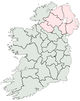
County Leitrim
County Leitrim (Irish: Contae Liatroma) is one of the twenty-six counties of the Republic of Ireland, and also one of the thirty-two counties of Ireland, located within the province of Connacht. It was named after the town of Leitrim (Irish: Liatroim). The population of the county is 28,950 according to the 2006 census.[1] Leitrim is the 26th largest of Ireland’s 32 counties in area and smallest in terms of population[2]. It is the smallest of Connacht’s 5 counties in both size and population.
History
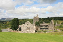
Leitrim countryside.
In ancient times Leitrim formed the western half of the Kingdom of Breifne. This region was long influenced by the O'Rourke family of Dromahair, whose heraldic lion occupies the official county shield to this day. Close ties initially existed with East Breifne, now County Cavan, and the O'Reilly clan seated there. The Normans invaded in the 13th century and occupied the south of Breifne. Much of the county was confiscated from its owners in 1620 and given to Villiers and Hamilton. Their initial objective was to plant the county with English settlers. However, this proved unsuccessful. British Deputy Sir John Perrot had ordered the legal establishment of "Leitrim County" a half-century prior, in 1565. Perrott also demarked the current county borders around 1583. Five forests are traditionally said to have stood in Leitrim up till the 17th century.
Leitrim was first hit by the recession caused by the mechanisation of [linen] weaving in the 1830s and its 155,000 residents (as of the 1841 census) were ravaged by the Great Famine and the population dropped to 112,000 by 1851. The population subsequently continued to decrease due to emigration. After many years, the wounds of such rapid population decline have finally started to heal. Agriculture improved over the last century. Leitrim now has the fastest growing population in Connacht.
Working of the county's rich deposits of iron ore began in the 15th century and continued until the mid 18th century. Coal mining became prominent in the 19th century to the east of Lough Allen in Sliabh an Iariann and also to the west in Arigna, on the Roscommon border. The last coal mine closed in July 1990 and there is now a visitor centre.[3] Sandstone was also quarried in the Glenfarne region. William Butler Yeats spent the turn of the twentieth century fascinated with Lough Allen and much of Leitrim. In the northwest, 11 km from Manorhamilton can be found Glencar Waterfall, which was an inspiration to Yeats and is mentioned in his poem The Stolen Child.
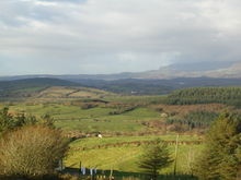
Geography
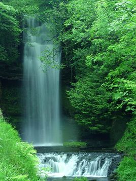
Glencar Waterfall at Glencar Lough.
Leitrim has a dramatic hilly and mountainous landscape in its northwest and is relatively flat in the southeast, each separated from the other by Lough Allen in the middle of the county. It is an unspoiled, tranquil area of great natural beauty, consisting of lofty mountains, deep valleys, pastures, lakes, rolling hills and rivers. Leitrim is not a landlocked county as it has a short length of Atlantic where Tullaghan lies. Coastline (5 km) between Sligo and Donegal in the northwest. Neighbouring Leitrim are the Ulster counties of Donegal to the north, Fermanagh to the northeast, and Cavan to the east, the Leinster county of Longford to the south and, to the west, the Connacht counties of Roscommon and Sligo. Fermanagh is in Northern Ireland while all the other neighbouring counties are within the Republic. Leitrim offers scenic panoramic vistas of Lough Allen and the River Shannon. The Shannon is linked to the Erne via the Shannon-Erne Waterway.
Lakes
- Lough Melvin is internationally renowned for its unique range of plants and animals.
- Lough Allen offers amazing views, especially from the road between Leitrim Village and Drumkeeran
- Lough Gill is to the northwest of Dromahair; Parke's Castle is located on the lake shore.
- Other particularly beautiful lakes include Lough Garadice, Lough Glenade, Lough Rynn and Lough MacNean.
Demographics
- Leitrim has the fastest growing population of any county in Connacht. As measured by census, the population rose by 12.2% between 2002 and 2006 to 29,000.[4]
- 2005 HEA statistics identified that Leitrim has the highest rate of participation in higher education in the Republic with 75% of 17-19 year olds being admitted to a higher course.[5]
- The county town is Carrick-on-Shannon (3,505 inhabitants)[6]. It is a highly developed, prospering river port on the River Shannon and many tourists hire cruising boats here to explore the Shannon and the Shannon-Erne Waterway -a 63 km canal linking the two river systems. It is amongst the fastest growing towns in Ireland having grown by 25% in the past few years.[7]
- According to 2008 statistics, Leitrim county has the third highest suicide rate in Ireland and the lowest male life expectancy at 72.8 years (average is 75.6).[8]
Transport
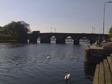
Bridge in Carrick-on-Shannon.
- Supplementing the local and regional road networks are the N15 (Sligo-Leitrim-Donegal), N16 (Sligo-Leitrim-Enniskillen) and N4 (Sligo-Leitrim-Dublin) national roads.
- Railway stations in Leitrim on the Dublin to Sligo line include Dromod and Carrick-on-Shannon.
- The Cavan and Leitrim Railway opened on 17 October 1887. It consisted of two branches, meeting at Ballinamore which connected Dromod and Arigna with Belturbet. Services carried goods, passengers and coal from around Lough Allen. Although protested, the line finally closed on 31 March 1959.
- Railway stations in Leitrim on the former Sligo-Enniskillen Railway included Dromahair, Manorhamilton and Glenfarne.
- The Shannon and Shannon-Erne Waterway give access to much of Leitrim by boat.
- Recently, proposals have been put forward to move Sligo Airport to a geographically better location near the village of Kinlough in County Leitrim.[9]
Towns and villages
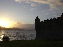
Lough Gill as seen from Parke's Castle.
- Aghamore
- Ballinaglrea
- Ballinamore
- Carrick-on-Shannon
- Carrigallen
- Cloonsheerevagh
- Cloone
- Drumahaire
- Drumcoura
- Drumcong
- Drumshanbo
- Drumsna
- Eslinbridge
- Fenagh
- Glenfarne
- Keshcarrigan
- Kiltyclogher
- Kinlough
- Killargue
- Leitrim,
- Largydonnell
- Lurganboy
- Mohill, Manorhamilton
- Newtown Gore
- Rossinver
- Roosky
- Tullaghan
Townlands
- Breandrum
- Bornacoola
- Cloonsheebane
- Cornashamsogue
- Dristernan
- Drum Reilly
- Effrinagh
- Gorvagh
- Lavagh
- Lisduff
- Fearnaught
- Shanraw
- Sheebeg
References
External links
|
Places in County Leitrim, Ireland |
|
| County town: Carrick-on-Shannon |
|
| Incorporated towns1 |
Ballinamore · Carrick-on-Shannon · Manorhamilton
|
|
| Unincorporated towns2 |
|
|
| Villages2 |
Aghamore · Ballinaglera · Buckode · Carrigallen · Cloone · Drumcong · Dromahair · Drumkeeran · Drumsna · Dromod · Eslinbridge · Fenagh · Fivemilebourne · Garadice · Glenfarne · Jamestown · Keshcarrigan · Kinlough · Kiltyclogher · Killargue · Largydonnell · Leitrim · Lurganboy · Newtowngore · Rossinver · Roosky · Tarmon · Tullaghan · Tully
|
|
| Townlands |
|
|
| 1 A C.D.P. with undefined boundaries and a population above 1,000. 2 A C.D.P. with undefined boundaries and a population below 1,000. |
|